Florenville Himalayan Footbridge Hike
06 November 2026
Starting point
Passerelle himalayenne de Sainte-Cécile, Rue de la Belle Hôtesse, 6820 Florenville
Duration
1h40
Difficulty
Difficult
This hike of approximately 7.5 km highlights one of the most original passages in the Semois valley: the Himalayan footbridge.
The route takes place in a very wooded environment, with a long climb towards the heights, several balcony sections and a striking panorama from the Roche du Chat.
The Semois remains the guiding thread of the loop, sometimes crossed, sometimes visible below from the forest paths.
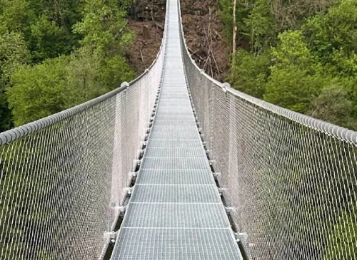
The route begins with crossing the Himalayan footbridge, suspended above the Semois river.
This passage immediately offers a beautiful feeling of height above the river, before joining the forest paths on the other bank.
After the footbridge, the path remains relatively gentle at first before gradually gaining altitude. The main ascent leads towards the woods and hills overlooking the Semois river.

View of the Semois river (© strava.com)
Himalayan footbridge : An iconic hiking passage, suspended above the Semois river.
The Semois : Central river of the route, crossed from the beginning and visible several times from the heights.
Roche du Chat : A major viewpoint on the hike, offering a panorama of the Semois valley.
After passing the Roche du Chat, the route gradually descends back into the woods.
At times, the Semois appears below through the trees, before joining the Himalayan footbridge again.
The end of the loop allows you to return to the parking lot after a route marked by crossing the footbridge, climbing through the forest and the panorama of the Roche du Chat.

Book with confidence

Quality assured

Authentic photos

Local & Here to help

Clear & Detailed

Family-run & Personal

